Showing 1–32 of 61 results
-
-
-
-
-
-
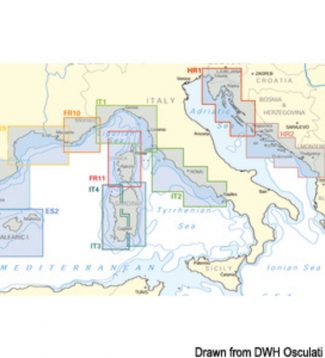
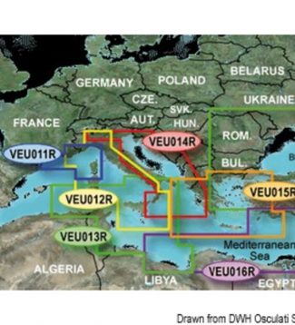
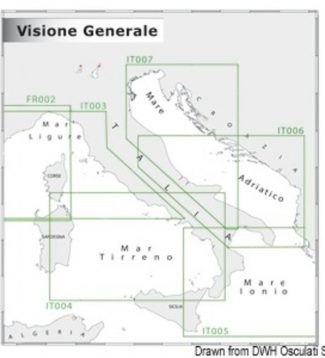
Cartography Navionics Platinum+ ITALIA LAGHI COSTE
Display real-time position direction speed and track. Bathymetrics navigation aids with Xplain � technology port services (gas stations mooring shipyards etc. With phone numbers where available) tides and currents.Verify that the instrument is capable of reading MSD-SD memory media greater than 2 GB in capacity.
-
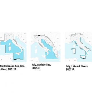
Cartography Navionics Platinum+ MAR ADRIATICO MAR IONIO
Display real-time position direction speed and track. Bathymetrics navigation aids with Xplain � technology port services (gas stations mooring shipyards etc. With phone numbers where available) tides and currents.Verify that the instrument is capable of reading MSD-SD memory media greater than 2 GB in capacity.
-
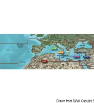
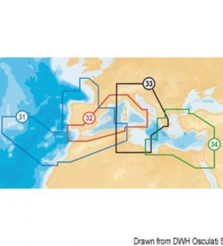
Cartography Navionics Platinum+ MAR MEDITERRANEO E MAR NERO
Display real-time position direction speed and track. Bathymetrics navigation aids with Xplain � technology port services (gas stations mooring shipyards etc. With phone numbers where available) tides and currents.Verify that the instrument is capable of reading MSD-SD memory media greater than 2 GB in capacity.
-
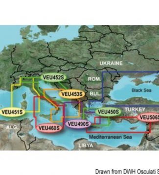
Cartography Navionics Platinum+ MAR TIRRENO E MEDITERRANEO CENTRALE
Display real-time position direction speed and track. Bathymetrics navigation aids with Xplain � technology port services (gas stations mooring shipyards etc. With phone numbers where available) tides and currents.Verify that the instrument is capable of reading MSD-SD memory media greater than 2 GB in capacity.
-

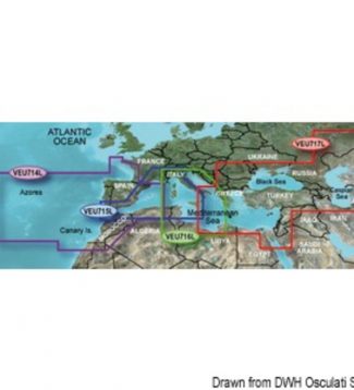
Cartography Navionics+ ITALIA LAGHI COSTE
Essential details including the port plans bathymetry list of phone numbers and much more. Hundreds of thousands of changes by theNavionics Community viewable on some GPS plotter compatible with Freshest Data. Access to any cartographic layers in the region purchasedSonarChart � the bathymetric map HD Navionics that reflects the ever-changing bottom conditions. Auto-routing SD /…
-
Cartography Navionics+ MAR ADRIATICO MAR IONIO
Essential details including the port plans bathymetry list of phone numbers and much more. Hundreds of thousands of changes by theNavionics Community viewable on some GPS plotter compatible with Freshest Data. Access to any cartographic layers in the region purchasedSonarChart � the bathymetric map HD Navionics that reflects the ever-changing bottom conditions. Auto-routing SD /…
-
Cartography Navionics+ MAR TIRRENO E MEDITERRANEO CENTRALE
Essential details including the port plans bathymetry list of phone numbers and much more. Hundreds of thousands of changes by theNavionics Community viewable on some GPS plotter compatible with Freshest Data. Access to any cartographic layers in the region purchasedSonarChart � the bathymetric map HD Navionics that reflects the ever-changing bottom conditions. Auto-routing SD /…
-
Garmin Bluechart G3 Charts Garmin Bluechart G3 micro SD regular
165,00 €Garmin is committed to provide extremely detailed cartography products and to ensure comprehensive coverage. The new marine chart BlueChart G3 offers state-of-the-art coverage, clear and detailed information integrated with data from Garmin and Navionics® charts. The new BlueChart also includes the Auto Guidance feature used to allow the chartplotter to automatically create a route to…
-
Garmin Bluechart G3 Charts Garmin Bluechart G3 Vision HD micro SD card small
220,00 €Garmin is committed to provide extremely detailed cartography products and to ensure comprehensive coverage. The new marine chart BlueChart G3 offers state-of-the-art coverage, clear and detailed information integrated with data from Garmin and Navionics® charts. The new BlueChart also includes the Auto Guidance feature used to allow the chartplotter to automatically create a route to…
-
Garmin Bluechart G3 Charts Garmin Bluechart G3 Vision micro SD card large
430,00 €Garmin is committed to provide extremely detailed cartography products and to ensure comprehensive coverage. The new marine chart BlueChart G3 offers state-of-the-art coverage, clear and detailed information integrated with data from Garmin and Navionics® charts. The new BlueChart also includes the Auto Guidance feature used to allow the chartplotter to automatically create a route to…
-
Garmin Bluechart G3 Charts Garmin Bluechart G3 Vision micro SD card regula
305,00 €Garmin is committed to provide extremely detailed cartography products and to ensure comprehensive coverage. The new marine chart BlueChart G3 offers state-of-the-art coverage, clear and detailed information integrated with data from Garmin and Navionics® charts. The new BlueChart also includes the Auto Guidance feature used to allow the chartplotter to automatically create a route to…
-

Garmin Gpsmap Plus 722 (xs) And 922 (xs) GARMIN chartplotter GPSMAP 723
1.069,00 €The new GPSMAP 723 and 923 chartplotters with sunlight-readable and highly backlit screen offer bright colours and crisp details for top light quality in any conditions. With their added processing power and new slimline design, it’s easy to retrofit these plotters in a wide range of dash configurations. Also available in the xsv version with…
-

Garmin Gpsmap Plus 722 (xs) And 922 (xs) GARMIN chartplotter GPSMAP 723 xsv
1.279,00 €The new GPSMAP 723 and 923 chartplotters with sunlight-readable and highly backlit screen offer bright colours and crisp details for top light quality in any conditions. With their added processing power and new slimline design, it’s easy to retrofit these plotters in a wide range of dash configurations. Also available in the xsv version with…
-
Garmin Gpsmap Plus 722 (xs) And 922 (xs) GARMIN chartplotter GPSMAP 923
1.599,00 €The new GPSMAP 723 and 923 chartplotters with sunlight-readable and highly backlit screen offer bright colours and crisp details for top light quality in any conditions. With their added processing power and new slimline design, it’s easy to retrofit these plotters in a wide range of dash configurations. Also available in the xsv version with…
-
Garmin Gpsmap Plus 722 (xs) And 922 (xs) GARMIN chartplotter GPSMAP 923 xsv
1.809,00 €The new GPSMAP 723 and 923 chartplotters with sunlight-readable and highly backlit screen offer bright colours and crisp details for top light quality in any conditions. With their added processing power and new slimline design, it’s easy to retrofit these plotters in a wide range of dash configurations. Also available in the xsv version with…
-
Garmin Gpsmap Plus 722 (xs) And 922 (xs) GARMIN GPSMAP 723 xsv + Radar GMR18 HD+
2.874,00 €The new GPSMAP 723 and 923 chartplotters with sunlight-readable and highly backlit screen offer bright colours and crisp details for top light quality in any conditions. With their added processing power and new slimline design, it’s easy to retrofit these plotters in a wide range of dash configurations. Also available in the xsv version with…
-
Garmin Gpsmap Plus 722 (xs) And 922 (xs) GARMIN GPSMAP 923 xsv + Radar GMR18 HD+
3.299,00 €The new GPSMAP 723 and 923 chartplotters with sunlight-readable and highly backlit screen offer bright colours and crisp details for top light quality in any conditions. With their added processing power and new slimline design, it’s easy to retrofit these plotters in a wide range of dash configurations. Also available in the xsv version with…
-

-
-
-
-

-
-
-
-
-
 Navionics Maps Navionics Platinum SD/Micro SD XL3 nautical chart
  Osculati Bow Roller With Anchor Locker Kit SS seesaw roller max 12 kg
 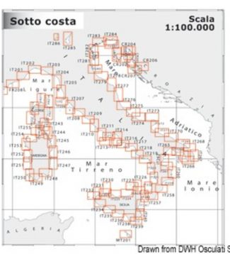 Navimap Marine Chart It 1:100.014 Navimap marine chart IT216-IT217