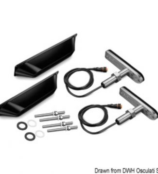
Garmin All-in-one Transducers For Echomap Plus Garmin SV stern transducer GT41-TM
455,00 €All-in-one transducers with traditional sonar functions. ClearVu/ SideVu.
Showing 2177–2208 of 21730 results

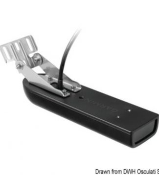
All-in-one transducers with traditional sonar functions. ClearVu/ SideVu.
All-in-one transducers with traditional sonar functions. ClearVu/ SideVu.
All-in-one transducers with traditional sonar functions. ClearVu/ SideVu.
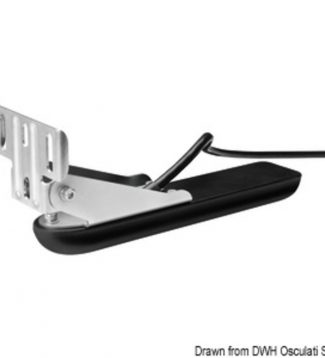
All-in-one transducers with traditional sonar functions. ClearVu/ SideVu.

All-in-one transducers with traditional sonar functions. ClearVu/ SideVu.

All-in-one transducers with traditional sonar functions. ClearVu/ SideVu.

All-in-one transducers with traditional sonar functions. ClearVu/ SideVu.

All-in-one transducers with traditional sonar functions. ClearVu/ SideVu.
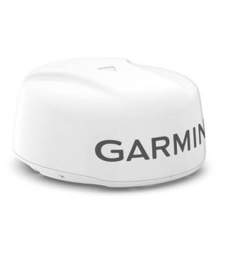
High definition of the targets on long and short detection ranges and minimal disturbances are some of the features thatdistinguish Garmin solid state radar antennas. In fact thanks to the pioneering Pulse Compression technology capable of maximizing the energy on the targets and the Pulse Expansion technology which concentrates the maximum energy on the targets…
High definition of the targets on long and short detection ranges and minimal disturbances are some of the features thatdistinguish Garmin solid state radar antennas. In fact thanks to the pioneering Pulse Compression technology capable of maximizing the energy on the targets and the Pulse Expansion technology which concentrates the maximum energy on the targets…
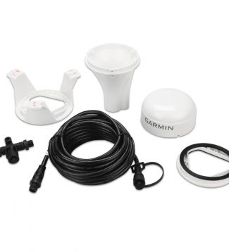
Extremely sensitive active antenna it can also be installed inside boats (structure permitting). Dual frequency GPS receiver provides location accuracy less than 1 meter away. Up to 10Hz update rate of position and heading data with extremely accurate values thanks to its 32-channel receiver. Supports the multi-constellation system: GPS GLONASS Galileo BeiDou. Multi-SBAS compatibility. Compass…
Extremely sensitive active antenna it can also be installed inside boats (structure permitting). Dual frequency GPS receiver provides location accuracy less than 1 meter away. Up to 10Hz update rate of position and heading data with extremely accurate values thanks to its 32-channel receiver. Supports the multi-constellation system: GPS GLONASS Galileo BeiDou. Multi-SBAS compatibility. Compass…
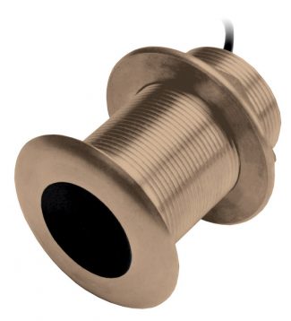
Transducer in bronze tilt 12 � frequency 50/200 khz to 8 pins with long cable mt.9. Not compatible for ClearVu functions

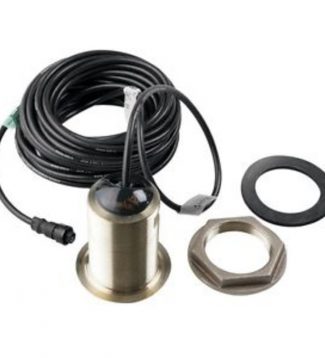
With Depth and Temperature operating frequency 77/220 kHz 500w with 9 mt cable (B619) Tilted 20� deadrise angles 15� a 25�
With Depth and Temperature operating frequency 77/220 kHz 500w with 9 mt cable (B619) Tilted 20� deadrise angles 15� a 25�
with Depth and Temperature 8 pin 600 w mwith 10 mt cable for GPS Map serie with chirp technology.
with Depth and Temperature 8 pin 600 w mwith 10 mt cable for GPS Map serie with chirp technology.
with Depth and Temperature 8 pin 600 w mwith 10 mt cable for GPS Map serie with chirp technology.
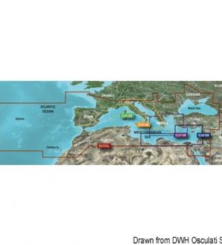
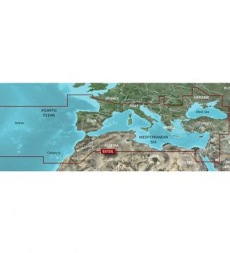
Garmin is committed to provide extremely detailed cartography products and to ensure comprehensive coverage. The new marine chart BlueChart G3 offers state-of-the-art coverage, clear and detailed information integrated with data from Garmin and Navionics® charts. The new BlueChart also includes the Auto Guidance feature used to allow the chartplotter to automatically create a route to…
Garmin is committed to provide extremely detailed cartography products and to ensure comprehensive coverage. The new marine chart BlueChart G3 offers state-of-the-art coverage, clear and detailed information integrated with data from Garmin and Navionics® charts. The new BlueChart also includes the Auto Guidance feature used to allow the chartplotter to automatically create a route to…
Garmin is committed to provide extremely detailed cartography products and to ensure comprehensive coverage. The new marine chart BlueChart G3 offers state-of-the-art coverage, clear and detailed information integrated with data from Garmin and Navionics® charts. The new BlueChart also includes the Auto Guidance feature used to allow the chartplotter to automatically create a route to…
Garmin is committed to provide extremely detailed cartography products and to ensure comprehensive coverage. The new marine chart BlueChart G3 offers state-of-the-art coverage, clear and detailed information integrated with data from Garmin and Navionics® charts. The new BlueChart also includes the Auto Guidance feature used to allow the chartplotter to automatically create a route to…
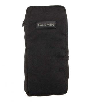
Protective carring case for all models Etrex Gpsmap
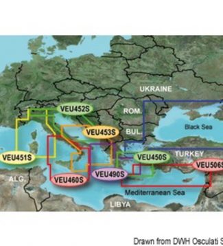
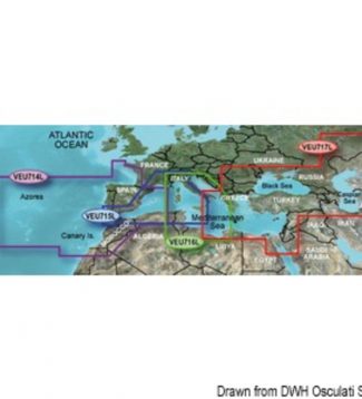
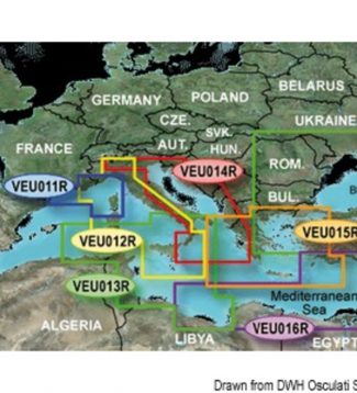
Auto Guidance 3.0 (*) automatically calculates the best route to reach the desired destination. Use the cartographic data to automatically process the best route to reach the set destination avoiding any obstacle along the navigation. Information on tides and currents indications on ports and services within the marinas.Bathymetric with detail every 30 cm for more…
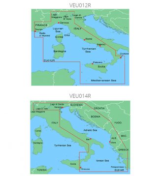
Auto Guidance 3.0 (*) automatically calculates the best route to reach the desired destination. Use the cartographic data to automatically process the best route to reach the set destination avoiding any obstacle along the navigation. Information on tides and currents indications on ports and services within the marinas.Bathymetric with detail every 30 cm for more…
Auto Guidance 3.0 (*) automatically calculates the best route to reach the desired destination. Use the cartographic data to automatically process the best route to reach the set destination avoiding any obstacle along the navigation. Information on tides and currents indications on ports and services within the marinas.Bathymetric with detail every 30 cm for more…
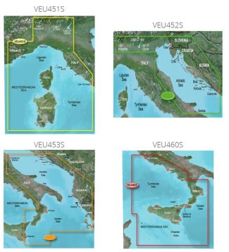
Auto Guidance 3.0 (*) automatically calculates the best route to reach the desired destination. Use the cartographic data to automatically process the best route to reach the set destination avoiding any obstacle along the navigation. Information on tides and currents indications on ports and services within the marinas.Bathymetric with detail every 30 cm for more…
Auto Guidance 3.0 (*) automatically calculates the best route to reach the desired destination. Use the cartographic data to automatically process the best route to reach the set destination avoiding any obstacle along the navigation. Information on tides and currents indications on ports and services within the marinas.Bathymetric with detail every 30 cm for more…
Auto Guidance 3.0 (*) automatically calculates the best route to reach the desired destination. Use the cartographic data to automatically process the best route to reach the set destination avoiding any obstacle along the navigation. Information on tides and currents indications on ports and services within the marinas.Bathymetric with detail every 30 cm for more…
Auto Guidance 3.0 (*) automatically calculates the best route to reach the desired destination. Use the cartographic data to automatically process the best route to reach the set destination avoiding any obstacle along the navigation. Information on tides and currents indications on ports and services within the marinas.Bathymetric with detail every 30 cm for more…
Extension cable mt.9 to 12 pin for transducers
Garmin All-in-one Transducers For Echomap Plus Garmin SV thru-hull transducers GT41-THP (pair of)
1 × 1.349,00 € Subtotal: 1.349,00 €